 drone-reviewm.com
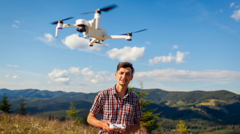
Whether you’re a professional drone pilot who takes pictures from high above for a living or a hobbyist still learning your way around the controls, the right apps can make all the difference in improving your flights. As a drone owner, you have to become familiar with a range of laws and regulations before you even purchase it, to avoid fines and keep yourself and others safe as you explore the skies. Keeping track of all that information as you fly your drone can be overwhelming, but there are apps that can help you stay in compliance with aviation rules at both the local and national levels.
That’s not all; there are also drone apps available to help you do everything from plan routes to monitor weather conditions. There’s no question that drones have opened up new opportunities for photography, surveying, and recreational flying — but getting the most out of the experience is about more than just good piloting skills. These five apps can support drone owners to enjoy and stay safe in the skies.
Aloft Air Control
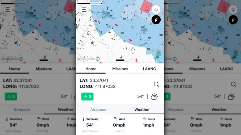
If there’s one app every drone owner should download, it’s Aloft Air Control. This all-in-one app is designed for individual drone operators looking for a comprehensive suite of tools to use during their flights. You can use the app’s tools for pre-flight planning, in-flight operations, and post-flight analysis to help you fly safely and stay compliant while out with your drone. When you download the app, you get access to its real-time airspace map that you can use for mission planning and maintaining situational awareness. The app’s integration with the FAA’s Low Altitude Authorization and Notification Capability (LAANC) makes it possible for users to get near real-time approval to operate in controlled airspace.
You can also use the app to access up-to-date information on airspace advisories and temporary flight restrictions, as well as to review current weather conditions, including wind speed and direction — all information you need to make an informed decision about whether it’s safe to fly. Its mission planning tools include customizable checklists and risk assessments. The app has automatic flight logging for supported drones when flown within the app, so you can keep accurate records of your operations. If you’re flying a DJI Air 3S or other drone using a native or third-party app, you can manually log your flight or import its flight logs. You can use the Aloft Air Control app on iOS, Android, and its web platform.
UAV Forecast
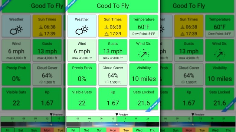
Weather is one of the biggest variables when flying a drone. That’s why drone owners often spend time checking weather forecasts to make sure it’s safe to fly. While there are a variety of free and paid weather apps for iPhone and Android, as a drone operator, you’ll often want more detailed information than what they provide. That’s where UAV Forecast comes in, providing drone owners with almost every detail they could possibly want to know about the weather. From the app, you can access hyperlocal weather data with detailed wind and gust speeds at ground level and various altitudes to help you accurately assess flight safety. You can use the app’s GPS satellite data, including Galileo and GLONASS, along with the solar weather (Kp) index to evaluate GPS reliability during a flight.
The app also provides hourly forecasts up to 15 days in advance, so you can get an idea of future weather conditions to plan for upcoming flights. Its flight condition analysis features automatic color-coded indicators — green for “Good To Fly” and red for “Not Good To Fly.” These indicators are based on the safety thresholds for wind speed, temperature, and other conditions that you’ve set in the app. The app is available for iOS, Android, and Mobile Web. While it’s free to use, if you want to take advantage of all the features, you’ll want to pay for a subscription. The value subscription costs $0.99 a month or $6.99 per year. More expensive subscriptions are available for drone pilots who want access to more advanced capabilities.
PhotoPills
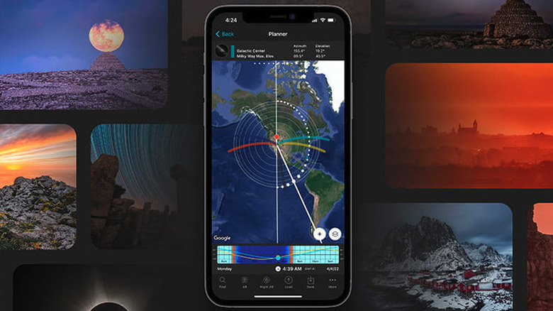
While there are a lot of technical things to take care of when flying a drone, for many operators, the best part of piloting a drone is getting the perfect aerial shot, and PhotoPills’ mission is to help you do just that. The PhotoPills app puts several tools at your disposal to help you plan ahead so you can capture photos in the best lighting conditions. Within the app, you can access The Planner, a 2D map-based tool designed for detailed photo planning. You can use it to pinpoint the exact time and location of the Sun, Moon, or Milky Way so you can be sure they’ll line up just right for your shot. The app also has a 3D augmented reality feature so you can visualize where the Sun, Moon, and Milky Way will be, making it easier to plan photos ahead of time.
You can use the app’s exposure calculators to compute equivalent exposures, long exposures, and time-lapse parameters to optimize camera settings for various shooting scenarios, or use the depth of field and field of view calculators to help you determine focus range and scene coverage. There are also widgets you can use to quickly access information about the Sun, Moon, and Milky Way, including rise and set times, phases, and visibility. PhotoPills is available for $10.99 on iOS and Android.
Tesla Magnetic Field Recorder
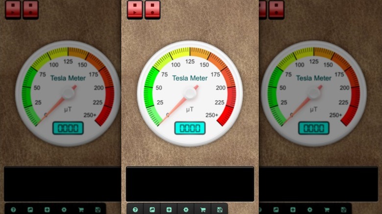
Testing for magnetic fields may not be the first thing that comes to mind when you think about flying a drone. However, it’s something you should consider doing. That’s because your drone’s compass relies on magnetic fields to navigate, and if there’s magnetic interference nearby — like metal structures or electronic devices — your drone could behave unpredictably. That’s what makes the Tesla Magnetic Field Recorder app for iOS so useful for drone operators. This app measures magnetic fields and metallic objects, helping you identify potential sources of electromagnetic interference (EMI) that could disrupt flight operations.
The app comes with several features that drone owners can immediately put to use. You can use it to measure electromagnetic field strength in microtesla units and assess environmental EMI levels. It can also detect nearby metallic objects that might cause magnetic interference to help you find safe take-off and landing zones. The app supports automated recording for monitoring EMI over extended periods or during specific flight operations. Real-time visualization features include a gauge displaying electromagnetic field strength and a diagram illustrating measurements across three dimensions. You can also turn on the optional sound feedback for easier monitoring when you’re not looking at the screen. You can use the full app for free, but there are upgrade options available if you’re interested in additional features.
Google Maps
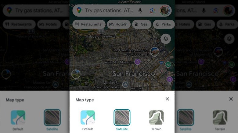
While you can’t use Google Maps to fly your drone, you can use its detailed satellite imagery and topographical data to plan your next flight. Google Maps really excels as a tool for finding new places to explore and the best launch spots for your drone. You can use it to measure distances, assess potential flight areas, identify landmarks, and get an idea of an area before you arrive on-site. The satellite map and street view let you visit the area virtually, making it easy to get a lay of the land before you leave home, while the terrain view can help you understand elevation changes so you can maintain a safe altitude and avoid obstacles during flights.
You can drop pins on places of interest as you scout locations to keep track of everything from potential flight areas to parking and scenery. The nice thing about using Google Maps is that you probably use it already and are familiar with how it works. As good as it can be for location scouting before a flight, you should keep in mind that it doesn’t explicitly highlight no-fly zones. However, you can check areas manually on Maps and input sensitive locations to avoid unauthorized flights. Google Maps doesn’t have real-time data on air traffic, weather conditions or temporary flight restrictions, so your best bet is to use it alongside another app that provides that information.
Source: http://www.slashgear.com/1754233/apps-drone-owners-should-have-installed/
You may also like

